


The Islands
Bem-vindo, Welcome!
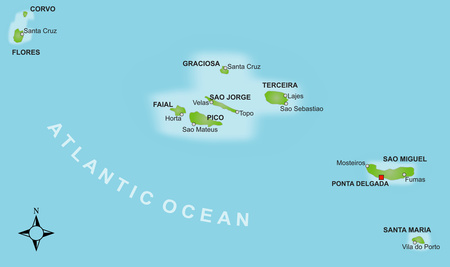
The Azores (In Portuguese: Ilhas dos Açores [ɐ'soɾɨʃ]) are an archipelago of nine inhabited Portuguese islands (main island of São Miguel), which are widely scattered in the Atlantic Ocean between Europe and America. According to their location, the nine inhabited islands are divided into an eastern (São Miguel and Santa Maria), a central (Graciosa, Terceira, São Jorge, Faial and Pico) and a western archipelago (Flores and Corvo). 600 kilometers are between the easternmost and the westernmost island, 300 kilometers separate the northernmost from the southernmost.
From an administrative point of view, the Azores have since 1976 formed an Autonomous Region of Portugal, the Região Autonóma dos Açores. Despite their comparatively large distance from mainland Europe, the Azores are thus part of the European Union as part of Portugal. Currency is also the Euro.
The Azores are a little world apart. If you are looking for peace, relaxation and intense nature experiences, here you are in good hands. To characterize the Azores in a few words is almost impossible: miles of flowering hydrangea hedges, deep blue crater lakes, historic towns, whales & dolphins, idyllic coastlines, lush green pastures with happy cows, rushing waterfalls, wildly romantic mountain ranges, snappy fishing villages and impressive volcanic craters.
The listing is far from complete. The scenic beauty of the Azores is beyond compare! Each of the islands has its own charm, natural paradises with huge craters of extinct volcanoes, imposing views of land and sea, historic places and centuries-old traditions. Due to the abundance of whales and dolphins some species live here, some take a break in transit. The Azores have become a world-renowned area for whale and dolphin watching. Somehow, the Azores are also a journey into the unknown. They are not a mass tourism destination. Luckily, one searches in vain for overcrowded hotels and large hordes of tourists. Instead, you can expect great hiking and cycling opportunities, tranquility, seafaring romance and sports such as scuba diving, sailing, canoeing or canyoning. Some speak of the Azores as remnants of the legendary Atlantis ...
In the magazine "National Geographic Traveler" the Azores were selected by 522 experts as the world's second-best island destination in the field of sustainable tourism with 111 islands to choose from. That means something! In spring 2012, the Coastal and Marine Union (EUCC) assessed around 1,000 tourist destinations from Scandinavia to the Mediterranean in the categories of nature, environment, identity and socio-economic. The Azores won first place and were awarded the Golden Prize as a destination for quality and sustainability.
General information
Agriculture and the sea are still considered the main donors to the islands. Many things that are manufactured industrially have to be imported. People secure their survival through a close family cohesion, some by remittances from relatives from abroad and receive their basic care through their own managed piece of land.
The Azores are assisted by the European Union. Thanks to generous subsidies, the archipelago is no longer one of the poorest regions in Europe. The progress of the islands, whether in terms of infrastructure or education, was and is primarily due to these EU funds. Almost all public works and renovations are carried out with funds from the European Regional Development Fund (ERDF).
More than 50% of the population works in agriculture, which means livestock and dairy farming in the first place. The agricultural sector is thus the most important economic sector in the Azores. Dairy products (mostly cheese) and live cattle make up the bulk of all exports, around 70%. Grown, on the other hand, is normally what you need for your own or for further processing industries.
Fishing means primarily catching and processing tuna. Since 2005, it can no longer be caught with nets, because the catch with leashes and hooks reduces the bycatch of dolphins and sharks and protects the coral reefs. Environmentalists therefore regard the Azores as one of the few regions in which sustainable fishing takes place. But not everything is perfect yet, unfortunately sea turtles are also being caught. However, it is being researched to form the hooks so that this problem can be solved. Tuna is processed and exported to the Azores. Other fish species are mainly used for their own supply and to supply the supermarkets and restaurants.
Another industry is tourism, which plays a more important role year after year.
Much of the industrial production takes place in São Miguel. Tobacco is processed, tea is grown, beer is brewed, sugar is processed and pineapples are grown. The tea plantations are considered the only ones that exist in Europe. The cultivation of pineapples in greenhouses are the most unique worldwide. On the numerous orchards you will find many passion fruits that are processed as a liqueur.
Plant life
The Azores are like a gigantic greenhouse. The original vegetation consisted largely of laurel forests and tree heaths, which are only partially seen today. The first settlers on all islands quickly cleared large areas and turned them into pastures and fields. So you can find real native species from earlier times usually only in less accessible places and in areas that are not used as pastureland.
The wealth of plants in the Azores, especially the westernmost island of Flores, is due to their location. Almost three-quarters of all plants today were introduced to the archipelago. On their way to and from America, migratory birds kept stopping in on the islands. They brought in their plumage unintentionally with a variety of seeds. In the ideal humid climate, the seeds thrive especially well, like in a greenhouse. A seed dropped into the ground, can then be left to itself. But the former landlords and rich orange barons have also contributed their part, as ornamental plants they shipped all sorts of plants for their private gardens, which increased and developed over the centuries.
The hydrangea is the most well-known flower of the Azores. Although it does not belong to the original vegetation, it has meanwhile spread in high hedges everywhere and is the figurehead of the archipelago. Their flowers in blue, purple or white, appear in July and August. You can begin to see the first flowers from the beginning of June until well into September.
In addition to the hydrangea, you can marvel at the flowering azaleas, agapanthus, garland flowers, arilies, camellias, lilies, wild callas, the canna flower and many other summer flowers. In the early autumn, the pink blooming Belladonna lilies stand out, which grow everywhere along the roadsides.
The mild and humid climate also allows exotic plants, such as palm trees and ferns to grow. Individual islands have a special microclimate in protected areas, where bananas, pineapples, oranges and especially wine thrive well. Widely used is the Japanese Cedar. Their wood is in great demand for processing construction, which is why it’s being reforested extensively for the production of timber.
In total, there are around 850 different flower and fern plants in the Azores, over 50 of which are considered endemic. The many mosses in the higher elevations are an indicator of the best air conditions. Over 400 species have been found thus far.
Animals
There are relatively few species of animals compared to plants. Birds are the only original animals that still occur in a large variety today. The Priolo, a bullfinch, lives only in the Azores and is a protected species. At night, the yellow-billed shearwaters are not to be missed with their strange screaming.
The most common among mammals is cattle. Like dogs and cats, it was introduced directly during colonization in the 15th century. Goats are another farm animal on the islands. Small lizards scurry around on lava stones, wild rabbits, hedgehogs and small rodents live in the undergrowth.
There are no dangerous or poisonous animals in the Azores. Also, snakes or scorpions luckily have not found the way here.
The biodiversity on land is made up for by a lush marine fauna. Puffer fish, groupers, parrot fish, barracudas, rays, moray eels and many more can be found in the waters, even small sharks and sea turtles pass by. There are also over 20 different whale and dolphin species. This includes the sperm whale, which was hunted until the late 1980s and processed industrially.
The islands of the Azores are the top of an 8,000-meter-high mountain range in the Atlantic Ocean. All nine Azorean islands consist of volcanic origin. Volcanic rock is difficult to date. Santa Maria is the oldest of the islands created about 8 million years ago, while Pico is the youngest with about 300,000 years. The eponymous volcano on the island of Pico is the highest peak in all of Portugal at 2,351 meters.
The Azores lie at 36° 43' to 39° 56' N and 24° 46' to 31° 16' W and cover a surface area of 2,330 square kilometers. This means that all the islands together are smaller than Mallorca's with a total area of over 3,500 square kilometers. They are part of the Mid-Atlantic Ridge and lie at the plate boundary between the Eurasian and the African plate. The westernmost islands Flores and Corvo are geologically already part of the North American continental plate. This is why they move an average of about 1.5 centimeters from the rest of the islands each year. Located south of the 40th parallel, the Azores are roughly at the height of Sicily.
The islands are scattered in the Atlantic Ocean. They are about 1,500 kilometers from Portugal and 4,000 kilometers from North America. The shortest distance (island Flores) to the North American mainland (Newfoundland in Canada) is 2,342 kilometers. The smallest island distance is located at 6 kilometers between Pico and Faial, the largest with 550 kilometers between Corvo and Santa Maria. Due to their scattered location, the islands are divided into an eastern group (São Miguel and Santa Maria), a central group (Graciosa, Terceira, São Jorge, Faial and Pico) and a western archipelago (Flores and Corvo). Except for Santa Maria and Graciosa, all islands are mountainous; their share of area is over 300 meters above sea level which is between 45 and 70 percent.
For volcanologists, the Azores are a unique field of research. The emergence of the Atlantic and the Azores is directly related to the movement of the tectonic plates. About 200 million years ago, drifting apart of slabs created the basin in which today the Atlantic Ocean spreads. This movement continues and increases the ocean annually by about 2.5 centimeters. At interfaces between the tectonic plates, magma can rise and surface. If this happens for several million years, more and more lava piles up and a submarine volcano emerges, which eventually protrudes above the sea level. A new island has emerged.
The volcanoes of the western group are considered no longer active, as are the volcanoes of Santa Maria and Graciosa. All others are considered active and the islands have been plagued by eruptions since their settlement in the 15th century. Nearly 30 outbreaks have occurred since then, about half of them on land, the other in front of the islands in the sea. The last scientifically proven eruption took place between 1998 and 2001 off the western tip of Terceira. Unforgettable is also the outbreak on Faial in the fall of 1957, which lasted almost a year and enlarged the island. Almost a quarter of the population left the island at that time.
The Azores are part of the Portuguese territory. Since 1976 they have an autonomous status and call themselves Região Autônoma dos Açores. Thus, they have their own government, but are still dependent on continental Portugal. The flag consists of two vertical stripes in blue and white and a hawk which gave the archipelago its name during discovery. It is framed by 9 golden stars, one for each inhabited island. Belonging to Portugal embodies the Portuguese coat of arms. However, the flag may only be hoisted next to the Portuguese, also a sign of dependency and affiliation. The islands are divided into three administrative districts: São Miguel and Santa Maria (with the district capital Ponta Delgada), Graciosa, Terceira and São Jorge (with the district capital Angra do Heroísmo), Faial, Pico, Flores and Corvo (with the district capital Horta). These three major districts are divided into 19, so-called Conçelhos, each with a main town. All in all, there are 149 communities known as Freguesias in these 19 Conçelhos.
Three cities were considered with governmental tasks, since they could not agree on a common capital. The regional government of the Azores with its president is based in Ponta Delgada, the parliament meets in Horta and the minister of the republic rules in Angra do Heroísmo. The parliament has 52 deputies from all islands and is elected every four years. With five deputies, the Azores are represented in the National Parliament in Lisbon.
Officially, the Azores were discovered by ships of the Portuguese Prince Henry the Navigator between 1427 and 1452. However, there are older nautical charts with markings that can represent the Azores. Flemish and Portuguese, nobles and peasants set out to settle the islands. They brought cows and plants with them, cleared the islands and farmed them. Already in the second half of the 15th century, almost all settlements along the coast were established and fortified ports were created.
In the 16th century, the Azores were a popular target of pirates. Treasures drowned after bloody sea battles on the seabeds, villages were destroyed. Volcanic eruptions and earthquakes did the rest. The dyeing and cloth manufacturers in Flanders demanded dyes that could be made from pastel and the dye plant Urzella. More and more grain acreage was abandoned in favor of the pastel. At the end of the century there was a great famine. In addition, 1580 Spain annexed Portugal and the regency lasted 60 years. However, the Spaniards were only moderately interested in the Azores. The exception was the port of Angra do Heroísmo on Terceira, which was also used by the Spanish fleet as a base in the Atlantic. Although the Spanish rule meant an economical crisis for the archipelago, the Azores lost their trading post in Angra when Portugal became independent again. With the introduction of the cheaper indigo from America, the demand for dye plants had also diminished. In the aftermath, the Azores were treated as a Portuguese colony, the stewards all came from the mainland and the welfare of the Azoreans was of concern to only a few.
In the 18th century, the archipelago began to develop into an important whaling center. American whaling boats hunted off the Azores, bought supplies on land, and hired brave men. A little later, the Azoreans with their own fleets went hunting for the sperm whales, which were then processed directly on the islands. Only in the late 1980’s whaling was prohibited.
The 19th century brought modest wealth to the islands. Whaling and the cultivation of oranges, tea and tobacco gained economic importance. The first steamboats commuted between Lisbon and the Azores and marked the beginning of transatlantic shipping. Towards the end of the century, Faial Island became a hub for telephone cables between Europe and America, bringing life, money and an international audience to the island.
Even in the 20th century, the Azores remained an important bridge between the old and the new world. Ships and seaplanes, submarine cables and telephone conversations ran across the Azores. Americans and allies took advantage of the favorable geostrategic location and built military bases and airports.
In 1932 Salazar became prime minister of Portugal, a long-lasting military dictatorship was born. He did not care about the islands and left the islands to an unscrupulous secret police, who repressed any opposition and made the people live in ignorance. During the reign of Salazar, the Azores stood stagnate in almost every respect. The archipelago was forgotten in the midst of the vast Atlantic Ocean. In 1974 there was the Carnation Revolution in Portugal, the dictatorship was then terminated. In response to decades of exploitation and disregard, the Azores had quickly formed a party that fought for independence from the Portuguese state. Due to this movement, the Azores were declared an autonomous region in 1976 with the entry of force into the democratic constitution in Portugal.
Islands
Volcanoes, deep black lava rocks, wine and many whales
Pico is the second largest island in the Azores. It is separated from the island of Faial by only six kilometers via the Canal do Faial. Pico is the highest mountain in Portugal, which gave the island its name. The mountain is a majestic volcanic cone with a height of 2,351 meters, which often carries a hat of clouds. The climb of the mountain is a unique, albeit exhausting experience. The efforts of the ascent and descent (good conditions required) will be rewarded with a fantastic panoramic view of the islands of the Central Group. Sulfur fumes at the summit indicate that the volcano is still active. But it is deep in its sleep, guarded by scientists. The last outbreak was in 1718.
Pico is 42 kilometers long and 15 kilometers wide, the surface is 447 square kilometers. Towards the east of the island a completely unpopulated plateau with smaller volcanic cones and craters keep larger herds of cattle and shimmering lakes in deep blue. The population of Pico is about 15,000 people. The island is surrounded by a coastal road where most villages are located. To the west is Madalena, the capital of the island, directly opposite of Faial. Located in the south is Lajes, São Roque do Pico is the northern coast. These are the three largest towns on the island, which also form the three administrative districts at the same time.
Volcanoes and wine
On Pico there are many volcanic caves, Gruta das Torres being the longest lava tube in Portugal. A portion is now officially accessible. It is located near Madalena and is definitely worth a visit (1-hour guided tours are available by scheduled appointments).
The coastal areas of the island form deep black lava rock, which is why Pico also has the nickname Ilha Negra, black island. The stones are the traditional building material for walls and houses. You can find whole villages of dark stone houses, which often have colored doors and window frames. Especially on the northern coast, starting from Madalena, the lava rock can be admired, often with visible traces of flowing lava. This is also the area of vineyards. Black lava stone walls run through the area, protecting the vineyards from the wind along with storing heat for the vines. The wine-growing region is now a UNESCO World Heritage Site. For centuries the cultivation of painstaking manual work has boded well for the wine makers. Until the mid-19th century wine trade on Pico island was legendary for the Verdelho grape, which was exported to the Tsar's house of Russia. Worth knowing is the history of wine and can be found at the Wine Museum in Madalena, which is housed in an old Carmelite monastery. There, grown in the gardens, are the largest dragon trees on the island.
Whales
In the 18th century, an important upswing was due to the large stock of sperm whales in the waters around the island. Pico became the island of whalers. It all started with American whaling boats hiring crew. Pico’s men were considered brave. In only 10 meters long boats, the men ventured out to sea and hunted the giant marine mammals with harpoons. A job not so safe. In the late 1980’s, whaling was finally prohibited in the Azores. Two museums show, in great detail, the history and importance of whaling: the Museo dos Baleiros in Lajes and the Industrial Baleia Museum in São Roque (a former whale-processing factory with original machinery).
But even today whales and boats play a big role. No longer hunted by hunters, but observed by observers. Over 20 different types of whales and dolphins can be observed around Pico, making the island one of the world's best whale and dolphin watching grounds. Due to the abundance of fish, enough food, over 3,000 meters deep and clean ocean water, are good enough reasons for whales to choose the best conditions for their habitat, or a break while in transit. Rarely, can you be as close to the gentle ocean giants as here. That's why scientists, photographers and tourists from all over the world come to the island of Pico for an unforgettable whale watching experience, and for many, the highlight of their Azorean vacation. Whale watching trips take place from Madalena and Lajes and are usually half-day excursions.
Hot springs, legendary crater lakes and urban life
São Miguel is the largest, highly populated and most influential island in the Azores. It belongs to the eastern group of the archipelago and has an area of 746.8 square kilometers. The island is 63.7 kilometers long and 16.1 kilometers wide. Around 140,000 people live in São Miguel, 40,000 of them in the capital of Ponta Delgada. Unlike the other sparsely populated islands, everything is a little different in Ponta Delgada, life is more anonymous. Some towns are bigger, the prices are a bit higher in comparison to the other islands, and the island is more touristically developed than the others.
Like all the Azorean islands, São Miguel mainly impresses with its natural beauties; panoramic crater lakes, rock formations, grass-covered volcanic cones, bubbling hot water springs. These are reminiscent of the volcanic origin of the island. But also pineapple plants that thrive in greenhouses (unique in the world), a tea plantation (unique in Europe) or the factory for the production of passion fruit liquor are worth the experience.
The capital Ponta Delgada
The tourist and commercial center is the capital of Ponta Delgada, a port city on the south coast. Monasteries, churches and palaces lend charm to some streets. The city has the main port of the archipelago and is the center of banks, insurances and other service providers. Even the few industrial companies and diplomatic representatives are located in and around the capital. Many shops, large hotels, city buses and faltering traffic make for an urban character. Ponta Delgada is an interesting stopover, but one can also choose the quiet and peaceful countryside along with authentic coastal villages for a stay.
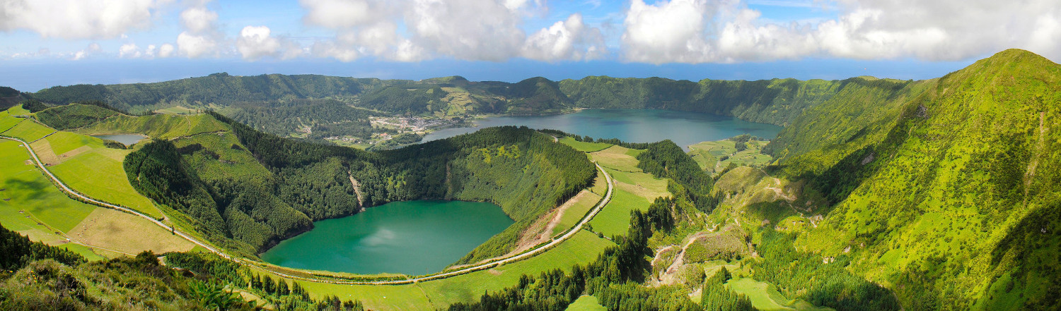
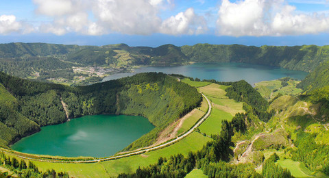
The crater lakes at Sete Cidades and the "blue tears of a princess"
The picturesque volcanic lakes, Lagoa Azul and Lagoa Verde, located in the west are among the scenic highlights of the island. From the view point of Vista do Rei, on the edge of the Caldeira de Sete Cidades, you can admire their full beauty. The huge crater, with over 12 kilometers of circumference, is one of the largest of the Azores. It is believed to have been built around the middle of the 15th century. The lake of Lagoa Verde owes its name to the greenish shimmer in the sunshine, which is caused by reflection of the steep, wooded crater wall. A narrow bridge separates the Lagoa Azul, the blue lake, from the Lagoa Verde. Even the dreamy village of Sete Cidades, to which numerous legends entwine, is worth a visit. Hustle and bustle of the capital are kilometers away.
Two adjacent lakes of different colors, a village named "Seven Cities", a place in beauty and seclusion: if not here, where should then legends and fairy tales arise? Once upon a time, there was a princess full with love for a poor shepherd. For years, the two should have met at the point where today a small bridge connects the lakes. One day, however, a young prince appeared before the king of the Seven Cities and stopped for the hand of the beautiful princess. The king consented to the marriage, against the will of his daughter, who fought bitterly. The king then forbade her to continue meeting with the shepherd boy. Secretly, they arranged to meet one last time. Both were crying bitterly. From the blue eyes of the princess and from the green of the shepherd so many tears flowed forming the two lakes ...
The valley of Furnas
A visit to the Furnas Valley, a long-extinct crater, is one of the highlights of the island. The small town of the same name, surrounded by beautiful parks, is a mixture of a well-tended spa town and a tranquil farm village, while the nearby lake invites you to relax. On its shores the traditional dish Cozido, a kind of stew, is cooked in dug-up holes with natural gases from the crater. In the village and on the lake you can find many steaming fumaroles. Those looking for peace and quiet on São Miguel can hardly choose a better place than Furnas.
The local Parque, Terra Nostra, is a piece of paradise. It is probably the most beautiful park in the entire Azores, where you can see rare trees and plants from all over the world. At the end of the 18th century, an American orange baron planted various trees around his villa, mostly from his homeland. The garden was born. In the 19th century the subsequent owners had the first watercourses built. Then enlarging the area to the park letting foreign horticulturists of international rank for development and care enter. In 1935, the Terra Nostra Hotel was built in the park, and the hotel management acquired the entire park and redesigned it.
An important volcanic eruption, an impressive Caldeira and the lively town of Horta
Faial is the fifth largest island in the Azores, with a surface area of 173 square kilometers. With a width of 14 and a length of 21 kilometers, it is quite round. The imposing Caldeira, a majestic collapsed crater, forms the island’s center. This is also the highest point of the island, providing a fantastic panoramic view. One can hike a circular trail along the crater rim, whose cauldron is about 400 meters lower. The entire area is protected by a natural conservation, so that all endemic plants are preserved. Of the island's 15,000 inhabitants, 6,500 live in the capital Horta, holding the Azorean parliament.
Faial is also called Ilha Azul, Blue Island, because of the many blue flowering hydrangea hedges. The colonization initiated the Flemish in the middle of the 15th century. Old red Flemish windmills, the village “Flamengos” (Flemish) and Horta (derived from Hurtere, the first Flemish on the island) still bears witness of the original Flemish settlers. Also, a German was amongst the early immigrants: Martin Behaim, originally from Nuremberg. He created his world-famous globe some time later and lived in Horta over 10 years. In the summer of 1867, the famous American writer Mark Twain came for a short visit.
Horta - a city with a past and a future
Horta has always played a special role, especially in the last century. Sometimes as a stopover for transatlantic flights, along with being a center of telecommunications between Europe and America. Today, the charming town of Horta, with its cosmopolitan atmosphere and its international marina, is on the sailing route of every transatlantic crossover.
In 1885, the first cable was laid from Lisbon to Horta, following the cable created to America. International telegraph companies settled and Horta soon became the most advanced city in the archipelago.
In 1919, the first seaplane landed in the port of Horta, thus initiating another important chapter in the history of the island. The stopover before Faial stood until the Second World War on the timetable of all transatlantic flights.
Today, Horta is an absolute must for sailors, especially Atlantic crossers. Over 1,700 sailors enter every year, immortalize themselves with creative and interesting paintings on the harbor walls and give the city its international flair. In the past, during the evening, people would meet for a gin and tonic at Peter Café Sport, arguably the most famous bar in the middle of the Atlantic.
Horta is undoubtedly a place with history that still has much to offer architecturally with its manorial buildings and is rightly considered one of the most beautiful towns in the Azores. In addition, extended city and harbor tours, church visits and various museums are worthwhile. Museums such as the local history museum with fig tree art, the whaling museum (in an old whale processing factory) or the Scrimshaw Museum displaying whale teeth art. The old harbor of Porto Pim invites one for sunbathing in a sheltered cove.
The volcanic area of Capelinhos
In 1957, of mid-September, an earthquake was registered on the western tip of the island, more quakes followed. Then an underwater explosion about a kilometer off the coast occurred. A new volcano was born. The sea seethed, ashes were thrown several kilometers high into the air, the western portion of the island was evacuated. For a year, the volcano raged and spat, totaling more than 30 tons of ash.
Today, Capelinhos is an almost vegetation-free ash desert, which resembles a lunar landscape. The so-called "New Land", which was created by the volcanic eruption at that time, is extremely impressive. An underground volcanic museum and information center was created in 2008. One of the best museums in the Azores, due to the architectural structure created in its natural form. Part of the museum is also the old spilled lighthouse, which was dug up again from the 2nd floor. After climbing 140 steps you will be rewarded with a spectacular view of the New Land and the spilled village along the grounds.
The hiking island
São Jorge belongs to the central group of the Azores. The island is 233.5 square kilometers, 56 kilometers long, eight kilometers wide between the neighboring islands of Graciosa and Terceira in the north and Faial to the west with Pico in the south. The mountain range has an average of 700 meters in height and 1,053 meters forms the backbone of the island. It drops steeply with breathtaking views. The main village is Velas with about 1,900 inhabitants, where old mansions still testify to a noble past. The remarkable church was constructed in the 15th century and has been modified since. A total of around 9,000 people live in São Jorge, many of whom still produce the dairy and continue to work the meat industry.
Cheese, coffee and handicraft
The cheese of the island is well known and is also exported to North America and other countries. The salty air and the evergreen high pastures give this island its special taste. The oldest dairy farm is the Cooperativa da Beira, founded in 1927. The processing plant has its own sales department and can be visited. A tour of the factory and the warehouses, in each of which up to 30,000 loaves of cheese mature, is recommendable. Almost every place on the island has its own milk collection site, and the farmers head out into the pastures twice a day to milk the cows.
Also traditional craftwork is capitalized on São Jorge. A must visit is Fajã dos Vimes: old hand-operated looms with woven tapestries and blankets, as processed a hundred years ago. In the same building you can find a small simple cafe. The coffee here tastes heavenly, just ask the owner. It becomes clear as to why, because behind the building there are countless coffee trees in the extensive gardens. Home-grown and home-roasted coffee in this special micro-climate within the steep slopes in these protected area. Also the cultivation of bananas are found in these areas.
The island's peculiarities include the so-called fajãs. Remote settlements with only a few inhabitants were built on shallow, fertile coastal plains below the cliffs directly on the sea. There are 46 of them in São Jorge, but not all are inhabited. You can find them everywhere along the coast, mostly idyllic, sometimes even without electricity.
A dream for hikers
São Jorge is perfect for hikers. It is probably a coincidence that "São Jorge", the namesake of the island, is also the patron saint of hikers. But it is fitting and a nice anecdote. The island is hardly developed touristically. The original landscape and magnificent vantage points offer grandiose views and photo opportunities. There is also a relatively dense network of trails, whether donkey paths or agricultural paths, which are often provided with hiking markings.
You have a panoramic view from Pico da Esperança, the highest peak on the island, an easy climb, and can easily be incorporated into a hike on the ridge. On São Jorge you can probably find the most beautiful hikes in the Azores: whether on the ridge, down into the many partially populated coastal villages, or from Fajã to Fajã, for every hiker there is a suitable way.
A must for hikers is the trail from the highlands down to Fajã de Caldeira de Santo Cristo, one of the most idyllic fajãs. This fajã’s lagoon is famous for its shells that thrive on the island. Hiking from the top of the trail you can find: the original laurel forests, the panoramic views down into the valley and over the Atlantic Ocean, countless hydrangea bushes and waterfalls (one with a swimming opportunity) make this hike so unique and popular. The path continues along the north coast, through an abandoned village to Fajã dos Cubres. The lagoon in Fajã dos Cubres has become popular with birds in this wetland.
Terceira - the third: Renaissance, volcanic cave and beach
Terceira is located in the center of the Azores and is an important hub for the Central Group islands. The more than 60,000 inhabitants are spread over a total area of 397 square kilometers, 29 kilometers long and 17.5 kilometers wide. The capital is Angra do Heroísmo located on the south coast of the island and is widely considered the most beautiful city in the Azores. There and in the town of Praia da Vitória is where most inhabitants live, most towns being on the coastline. The interior part of the island is rough and has uninviting living conditions. The island is characterized by livestock, covered by fields and enclosed in dry stone pastures. Around 50,000 cattle graze in the pastures, including some magnificent bulls, which are bred for the Tourada à Corda, (the bullfighting on the road a peculiarity of the island). For centuries, the island profited like no other, from the Spanish and Portuguese boats anchored with treasures from all over the world in the sheltered bay of Angra. Even today, magnificent buildings are reminiscent of the glittering epoch. This wealth attracted the pirates, Sir Francis Drake who also appeared in front of the island. Thus, about 50 fortifications were built around the island for protection, of which some are still visible today.
Incidentally, Terceira owes its name to the fact that the island was discovered by Portuguese sailors as the third island of the Azores in the 15th century. Coincidentally, Terceira is also the third largest island in the archipelago.
Angra do Heroísmo - a significant Renaissance city
Angra was founded in the 16th century and was the first town in the Azores to receive city rights. The great seafaring age, where many stopped in Angra, gave the city a rapid upswing. A thriving and magnificent Renaissance city was born. Twice, the island metropolis was proclaimed, capital of the country in the history of Portugal. In the 19th century, Angra lost its importance as the economic, administrative and cultural center of the Azores, while the rise of Ponta Delgada, today's capital of the island of São Miguel, began. In 1983, the old town of Angra do Heroísmo was declared a World Heritage Site by UNESCO. The reason for the survey was that the city was an important link between the cultures of Africa, America, Asia and Europe.
In the 15th and 16th centuries the exploration of the oceans is still reflected in their architecture today. As of today, the neat, historic district that stretches around the bay is dotted with boutiques and cafés, locals and tourists stroll along its lanes past palaces, mansions, monasteries and churches. The modern marina attracts sailors from all over the world.
What else Terceira offers
Next to Angra there is another town on the island, Praia da Vitória. Praia means beach, approximately one kilometer of long sandy beach, was considered to be one of the most beautiful in the entire Azores until the 1980’s. Today, two mighty dams separate the bay from the open sea to the detriment of aesthetics, but for the benefit of the economy. In addition to the flagship city of Angra, Paria da Vitória has long been considered of less importance. But the town is becoming more charming. There are some good accommodations, a beach promenade was created, streets were restored and a marina was constructed. Despite the jetty it does not feel like you are swimming in a harbour area, and the sandy beach at your doorstep is the cherry on the top of the cake.
The volcanic cave Algar do Carvão, in the middle of the island is worth seeing. It is 100 meters deep and more than 2,000 years old. Through the former chimney of an extinct volcano and into the interior of the island are stairs, passing stalagmites and stalactites, you end up at a small lake. The cave is also home to a spider species that are found nowhere else in the world.
There are also wonderful hiking trails on Terceira, but the island cannot compete with Pico, São Jorge or Flores. For hikers, other islands are certainly more suitable.
Windmills, tranquility and a unique volcanic cave
Graciosa is the loveliest and the second smallest island in the Azores. Located in the north it forms the central group of the archipelago (Faial, Pico, São Jorge and Terceira).
It covers an area of 60.84 square kilometers and has an oval shape. The largest north-south extension is 10 kilometers and the largest east-west extension is 7 kilometers. The main town is Santa Cruz da Graciosa with about 1,800 inhabitants. The entire island is only inhabited with about 5,000 people. Graciosa is not only small but also relatively flat. The highest elevation is 402 meters. This distinguishes this island from the others. The interior is populated and not all villages are located on the coast. The hydrangea hedges, which are widespread on the other islands, are more of an exception on Graciosa. There used to be around 30 windmills. As of today there are still three in operation. They are reminiscent of windmills from Flanders with their design and are a popular photo opportunity. Compared to other islands little livestock farming is operated. Horses and donkeys are still the most important means of transport, and cows have their own traffic signs. The most beautiful places and attractions of the island can be discovered by car in one day.
Caldeira and Furna do Enxofre
To the south is a large Caldeira, a volcanic cauldron about 1.2 kilometers in diameter, with Graciosa's main attraction at its center, the Furna do Enxofre. This unique cave descends through a stairwell in the middle of a volcanic vent. It is called a volcanic miracle by experts. A visit is like a journey back in time to the underworld of the island. The scenery is picturesque as a movie-scene. The last eruptions took place very long ago. The volcano that created Graciosa is now classified as no longer active. Inside the cave, after descending 184 steps, visitors can expect stinging sulfur fumes and a dark lake, from which the peasants used to fetch water for their livestock. Lunchtime is best for a visit when the sunlight shines through the volcanic vent.
Even a prince from Monaco was fascinated by the cave at the end of the 19th century. The oceanographer and geologist Prince Albert of Monaco, the grandfather of the present prince, sailed over half the continent in 1879 to explore the cave and at that time one had to descent with a rope ladder.
The island known for its flowers
Flores is the fourth smallest island in the Azores and geographically located on the American continental shelf. Covering a total area of 143 square kilometers, 11.5 kilometers wide and 16.5 kilometers long, where only about 4,000 people live. Due to their location the island is very safe, since there were no more volcanic eruptions during a long period of time. The interior of the island, with high mountains, rushing streams and impressive waterfalls is mainly deserted. In addition to some small villages, there are two larger towns, Santa Cruz das Flores and Lajes das Flores. Flores was considered, for a long time, very poor and many migrated due to their remote location to the larger islands of the archipelago. It was not until the mid-20th century that modernity arrived. The Portuguese navy established a base on the island and the French set up a monitoring system for international radio communications. In the following years there were significant improvements in the infrastructure, along with the airport being built. But the television premiered on the island, which existed only for the Football World Cup in 1986, a time when some islanders had never worn shoes in their lives.
The western tip of Europe - a paradise for nature lovers
Fajã Grande is the westernmost village in Europe, even though, as a small anecdote, a village in continental Portugal claims the same. Fajã Grande is a wonderfully idyllic village with beautiful hiking opportunities, swimming in the sea and rushing waterfalls. The name Grande, which means big, is misleading. This is not about the size of the place, but about the size of the Fajã, the headland itself.
On Flores you can admire a unique variety of plants and colors, thanks to the migratory birds, which brought the seeds in their plumage. As stated in a brochure of the Azorean Tourist Office: "green pastures bordered by lush hydrangea hedges, waterfalls, crater lakes and flowers and more flowers make up the unique beauty."
But it is not just the flowers that make this island so unique. Rugged sloping cliffs, dense moss carpets, endemic laurel forests, densely spaced crater lakes and bizarre rock formations are also included. It is nature in itself, and the deep tranquility and serenity that lies over the entire island.
The Rocha dos Bordões, one would translate it as "bar-shaped cliffs". It is arguably the most impressive geological formation in the entire Azores. More than 200 huge vertical basalt columns tower up to 28 meters in height. They are of breathtaking beauty and an important landmark of the island.
Because of its geological, botanical, scenic and cultural wealth, Flores has been on the list of UNESCO biosphere reserves since 2009, along with the neighboring island of Corvo.
Flores is at the top of the list of one of the most beautiful of the Azores islands, even though it receives most of the rain falls and the strongest winds.
The island for a day trip
Corvo is the smallest and northernmost island, it was created from just one volcano. The last time it was active was about 2 million years ago. Only 6.1 kilometers long and 3.8 kilometers wide, the island has a total area of 17 square kilometers. Like its neighboring island of Flores, it lies on the American continental shelf. Yearly it distances itself from the continental drift by a few centimeters from Europe. Corvo has only one village, Vila Nova, with less than 500 inhabitants. It is the smallest municipality in Europe with city rights. Also, there is only one road outside the village. At the top of the impressive collapse crater, the road ends after about 7 kilometers and dead-ends in the middle of the island. The giant crater covers 3.5 kilometers, created from this volcano. Because of its mighty dimensions, it was called caldeirao" (which is the male form), instead of "caldeira" (the female form).
The "Corvinos", as the inhabitants of the island, form a community of a special kind. They have always been a sworn community that helps and assists one another.
Until the 1980s, many Corvinos were not able to get beyond their island or even the neighboring island of Flores due to their secluded location. With the construction of the airport, this changed and the isolation began to loosen. But until today, they have preserved their ancient language, due to the long-lasting isolation, archaic forms in their dialect are unmistakable. A few years ago, a study was carried out in Lisbon. It would be cheaper for the Portuguese Government to provide all residents of Corvo with a lifetime in a good hotel in Lisbon than to maintain a functioning infrastructure on the island.
Corvo is a paradise amongst ornithologists. Many different birds can be observed on other islands, but you do not have to look for them on Corvo. There are very few trees and shrubs on the island that would serve as hidden resting places for the animals. Together with the neighboring island of Flores, Corvo is on the list of UNESCO Biosphere Reserves.
Corvo is a great day trip from Flores, with arrival in the morning by boat. It's best to drive up to the crater because of the impressive views into the crater. From here, one can hike back to the village comfortably on the road that is only used by a few agricultural vehicles. It is worthwhile to stroll through the streets, where you will find cafes and pubs. The return to Flores by boat in the afternoon is an amazing experience with the view of Flores. You may be lucky to be accompanied by a school of dolphins.
Sun, beach and sea
Santa Maria is geologically the oldest and also the sunniest island in the Azores. At about 97 square kilometers, about 5,500 people live here. It’s the third smallest island in the archipelago after Corvo and Graciosa. The western half of the island is very flat. The airport, as well as a new developed area, determine the image of the wide plain. The main town of Santa Maria is Vila do Porto. The mountainous eastern part of the island presents itself quite differently: enchanted forests, pretty small houses, inviting bays with bright sandy beaches that characterize the landscape. The island is very laid back. It’s infrastructure has only a few accommodations to offer. It is the perfect place for peace seekers to relax. The island is most known for the most hours of sunshine, the least rainfall, wide beaches, romantic bays. It is also ideal for swimming, sunbathing, snorkeling and diving, along with walks on comfortable paths that lead through the eastern evergreen hill country.
A paradise for divers
There are a small archipelago called Formigas, only 37 kilometers off the north coast. It consists of some rocks, some of which protrude only a few meters from the sea. Many captains sailed around these rocks at a safe distance since they were so feared, yet many ships crashed here. Today, boats head directly to the rocks, due to the abundance of fish providing the best diving in the world. You can find sharks, tunas, rays, mantas and much more here in these waters. Therefore, the Formigas are also a popular destination for deep-sea anglers. These rocks are also known for the nesting place of rare seabirds which are protected.